Progress: Establishing a stream typology
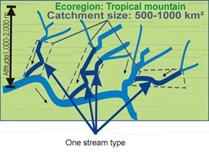
A stream typology was established in the partner countries to assign rivers with comparable natural environmental conditions to a certain stream type. As a result of a comprehensive literature survey as well as of the partner's expertise, the WWF 200 ecoregions have been selected as appropriate eco-geographic units. Within this framework of ecoregions, a more detailed river typology for the HKH region has been generated, which in addition is based on catchment size, altitude, and other criteria, such as the tidal influence in the Lower Gangetic plains of Bangladesh (see also: » River and stream typology).
 | Arrows indicate streams that belong to the same stream type since they are situated in the same ecoregion (Tropical mountain), belong to the same catchment size class (500-1000km2) and altitude class (1000-2000m). |
The following five ecoregions and eleven sub-ecoregions (bioregions) have been selected as study area:
- 1. Eastern Himalayan Broadleaf Forest (IM 0401)
Inner Valleys and Passes in Western and Central Bhutan
Mid-hills and Mahabharata Range in Nepal - 2. Himalayan Subtropical Pine Forest (IM 0301)
Southern Mountains and Gorges in Bhutan
Middle Mountains and Valleys in Nepal
Almora hills in the Kumaon Himalaya in India
Muree Hills in the Islamabad Region in Pakistan
- 3. Western Himalayan Broadleaf Forest (IM 0403)
Indus River Basin (catchment of Tarbella Reservoir) in Pakistan - 4. Lower Gangetic Plains Moist Deciduous Forest (IM 0120)
Padma and Meghna River Basin in Bangladesh
Terai in Nepal - 5. Upper Gangetic Plains Moist Deciduous Forests (IM 0166)
Siwalik/Terai in India
Among these ecoregions/bioregions the following detailed stream typology has been applied:
Core stream type: Himalayan Subtropical Pine Forest (IM 0301)
Sampled in Bhutan, India, Nepal and Pakistan
Characterization:
- catchment area of 50-500 km2
- altitude range of 500-2000 m asl
- ecoregion of Himalayan Subtropical Pine Forests
- Predominantly silicious catchment geology
Other stream types to be sampled:
Eastern Himalayan Broadleaf Forest (IM 0401)
Sampled in Bhutan and Nepal
Characterization:
- catchment area of 50-500 km2
- altitude range of 1000-2500 m asl
- ecoregion of Eastern Himalayan Broadleaf Forests
- predominantly calcareous catchment geology
Western Himalayan Broadleaf Forest (IM 0403)
Sampled in Pakistan
Characterization:
- catchment area of 50-500 km2
- altitude range of 1000-2500 m asl
- ecoregion of Western Himalayan Broadleaf Forests
- predominantly calcareous catchment geology
Lower Gangetic Plains Moist Deciduous Forest (IM 0120)
Sampled in Bangladesh and Nepal
Characterization:
- catchment area of 500-1000 km2
- altitude range of 45-250 m asl
- ecoregion of Lower Gangetic Plains Moist Decidious Forests
- predominantly alluvial deposits catchment geology
Upper Gangetic Plains Moist Deciduous Forests (IM 0166)
Sampled in India
Characterization:
- catchment area of 500-1000 km2
- altitude range of 45-250 m asl
- ecoregion of Upper Gangetic Plains Moist Deciduous Forests
- Predominantly alluvial deposits catchment geology